
Dr. Kuerden's Road Through Pilling in 1684
By W. H. Lawrenson
During a general clear out in the basement of Townley Hall, Burnley in 1952 a bundle of manuscripts came to light. These turned out to be a series of road maps and town plans of north-west showing in detail the road through Pilling. The making of these maps Lancashire, which included the road from Lancaster to Poulton and has been attributed to one, Richard Jackson, and dated to around attending Leyland Grammar School seems to have spent the next 25 1684. Jackson was born in Cuerden near Leyland in 1622/23 and after years of his life at his studies which included spells at Oxford and Cambridge Universities before he finally qualified as a Doctor and began to practice in Preston where he became known as Doctor Kuerden. He seems to have liked this title and it stuck to him for the rest of his life.
He was of a scientific turn of mind with a keen interest in antiquarian matters and historical research. He must also have been an accomplished surveyor which is shown by the quality of his maps. I suspect that he must have spent more time at his hobbies than he did at his actual doctoring. These interests brought him into contact with Christopher Townley of Townley Hall and in Townley he found a kindred spirit and from then on they became firm friends and worked together at their historical researches.
So we can try to picture the good doctor entering Pilling on his map making expedition complete with his writing box, ink bottle and quill. Perhaps mounted on horse back to give him a better view of the road and countryside, busily sketching in the course of the road and habitations as he passed along, while by his side his assistant trundling along a measuring wheel, reading off the distances they had covered to be added to his map.
These distances recorded all along the road from Lancaster to Poulton are surprisingly accurate. Townley to accompany the doctor on these expeditions, for he would It would seem to make sense for have the introduction and access to the homes of the good and the great along their way. He must have asked the locals the names of the villages as he passed through, because his spelling of the village names is exactly the way they would have been pronounced locally and indeed as they were up to about 60 years ago. So, Stalmine was Stalmin, Preesall was Preesa, and Poulton was Pooton.
We must remember that the roads that he was travelling along were very different from the roads we know today, being little more than sanded tracks open to the fields with little if any permanent little there was would be confined to short journeys and that mainly fencing. Very little wheeled traffic would be seen on them and what in the summertime, and farmers carting to and fro from their farms to their fields. Repairs to the roads were so often neglected that travellers were forced to make detours onto the neighbouring fields which of course led to a great deal of friction with the land owners. For instance, in 1670, John Thornton of Pilling appealed to the Justice of the Peace saying 'the road across his land, by neglect, would shortly be lost and travellers were forced to go over his land much to his great loss’. He asked his worship to order the said inhabitants to be compelled to make repairs to the said road. He must have had some success because on the 6th October, 1670 the court sessions ordered the inhabitants of Pilling to repair their roads under the threat of a £10 fine.
A little later, an effort was made to force the people of Pilling to add stone to their roads. They successfully appealed against the order saying that stone was not readily available in the area, but it was more likely to have been a case of indifference and an attitude that what had been good enough for their fathers was good enough for them.
Owing to the dreadful state of the roads, the main means of transportation was by trains of packhorses. These trains generally consisted of about 20 horses each carrying a load of 1 cwt and led with an old horse furnished with a bell known as 'The Bell Horse'. With young horses or short journeys each horse could carry up to 2 cwt. Road maintenance such as it was, was the responsibility of the Parish through which it passed. Farmers were ordered to provide horses and carts in numbers proportionate to the size of their holding to cart in sand for the roads' maintenance. In Pilling, road sand was dug and carted from three sites. These were Lane Ends, Mill Bridge and Lazy Hill (Ladies Hill).
Immediately the map makers enter Pilling at 'Wrampa' (Wrampool) we are confronted with something of a puzzle, or perhaps we can detect some kind of a clue to the maps purpose. We will see that in the previous ten or eleven miles from Lancaster to Pilling only two people are mentioned Mr. Spencer at Ashton Hall and Mr. Dalton at Thurnham Hall while in the eight or so miles from Pilling to Shard, again only two people are mentioned Mr. Nixon at Preesall Park and Charles Shuttleworth at Shard itself. However, in Pilling alone in about a distance of a mile and a half, the names and dwellings of three people who, on the face of it, are just ordinary villagers, are shown. They are George Bradshaw at 'Wrampa', Ann Jollys down Wheel Lane and William Carter at 'Hooles Farm', while the owner of Pilling Hall does not even get a mention.
George Bradshaw at 'Wrampa' was a farmer and salter, working the salt-cotes there and seems to have been a man of some substance. His was one of the names attached to a petition made to the Justices of the Peace in 1696 pleading for Parish relief to be granted to the village after a devastating storm and flood in the March of that year, which left some forty families homeless and destitute, and which in the end, through the loss of stocks of salt and destruction of the salt houses, proved to be a blow from which the Pilling salt industry was never able to recover.
Of Ann Jollys and William Carter nothing seems to remain to allow us to picture them or the lives they led.
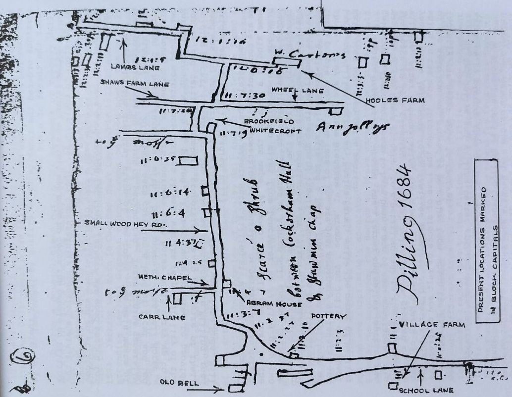
He shows the road to Pilling Chapel, the village's first church - probably of Saxon origin at Newer's Wood running straight on from the 'T' junction at Lane Ends Farm. The chapel's curate at this time would probably be Richard Harding.
His positioning of a windmill at first sight, apparently standing well onto the saltmarsh and very exposed to all the storms and sea, seems very strange, but if we study his map we will see that the road the doctor followed ran further inland than the present one, keeping close to the old earth embankment which would position the mill on the slightly higher ground near the present sewage works. It may have been only a peg mill used during the summer months when the flow of water was insufficient to turn the old water mill which had been in existence since at least the 13th century.
He crosses the Broadfleet by means of a wooden bridge which had to be rebuilt in 1652 and which seems to have stood a little up stream from the stone bridge and closer to the old water mill, the site of the present mill. On the 'T' junction at the Golden Ball Hotel he gives two routes to 'Stamin' (Stalmine). To the right "Stamin by ye sands" and to the left down School Lane "Stamin by ye moss". This moss road ran along the very edge of the moss lands (Head Dyke Lane) and would be bad even in the summer months, but quite impassable in the wintertime. The sands road ran over Lazy Hill down Fluke Hall lane, Ridge Farm, Cockers Dyke onto Pilling Lane through Preesall to join the summer road at Preesall Park and so on to Stalmine.
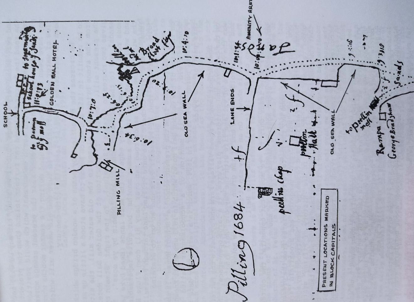
Across the road from the present school a 'School House' is shown on the site of the Golden Ball Hotel which in 1833 was still known as School field. There is mention of a schoolmaster called Mr. P.J. Wallis being at Pilling in 1604, which is a very early date for this part of the Fylde.
Down School Lane he shows Village Farm and opposite the Pottery, on the car park and childrens' play area, is a large open space. This was the centre of village life with the Maypole, Bull Ring, Cock Pit and the Pinfold. At the end of the green a private house now called The Old Bell is shown. On an early map it is named as the Bell Inn and on a map of 1833 it is called The Blue Bell.
Carr Lane leads only to 'Ye moss' but opposite, the cottage which used to stand against Abram House is shown.
Along Smallwood Hey the Doctor's road deviates from the present one, turning behind 'White Croft' bungalow and Brookfield farm- house to join Shaw's Farm Lane and to emerge onto 'Smallwood Hey again opposite Wheel Lane. Mr. Sobee in his 'History of Pilling' states that the road from Wheel Lane along Lambs Lane and Head Dyke Lane was constructed by Captain Dickinson in 1780, but this can clearly not be the case because here we have the roads shown in 1684. What probably occurred is that the old sanded track was remade with stone and made fit for wheeled traffic at that time.
So, after naming the abodes of Ann Jolly's down Wheel Lane and William Carter at Hooles Farm, which in the 18th century was owned and rebuilt by Captain Dickinson, the question as to why in the days before universal travel such detailed maps showing precise distances along the road were made in the first place.
Certainly these were very troubled times with the Catholic and Protestant factions becoming very nervous about unfolding events.
Do we therefore detect perhaps a military or political reason for these maps? Up to date, no convincing argument has been advanced as to the motive behind the map making so we are left to detect any clues the doctor has left us and to draw our own conclusions.
Sources
L.C.C Records Office Cat No DDX194
The History of Pilling
Lancs. Local Historian Vol. 6, 1991.